 Dr. Ron Counts
Research Assistant Professor
Associate Director, Mississippi Mineral Resources Institute
rcounts@olemiss.edu
662-915-7320
111 Brevard Hall, University, MS 38677
ResearchGate: Ronald_Counts
ORCID: https://orcid.org/0000-0002-8426-1990
Experience
Education
Research interests
My research focuses on understand the dynamics behind the paleoenvironmental changes and landscape evolution that occurs due to natural geologic process, gradual and abrupt climatic fluctuations, neotectonics, and anthropogenic activities. This is done by using geologic and geomorphic mapping to understand the processes acting on a landscape; luminescence (OSL, TL), terrestrial cosmogenic nuclide (TCN), and radiocarbon geochronology to quantify process rates and rates of change; and sediment coring, shallow geophysical methods, and the analysis of cores to build geologic frameworks that can be used to develop 3D and 4D landscape models.
Current Research
 Determining the age and extent of the Adams Mill fault at the Smithsonian National Zoological Park, Washington, D.C.
M.S. student: Kristian Macias, 2020-2022
Collaborators:
U.S. Geological Survey Earthquake Hazards (Tom Pratt)
U.S. Geological Survey Luminescence Dating Lab (Shannon Mahan)
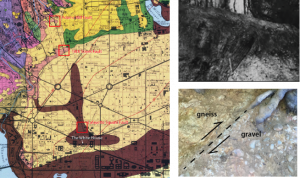
Geologic map of Washington DC; red boxes, from north to south, are the Adams Mill fault at the Smithsonian National Zoo (shown in photos to the right), a fault at 18th Street near California NW, and Lafayette Park.
Geophysical surveys are being used to map an inferred geologic fault that may lie under our nation’s capital. Luminescence dating from a hand-dug pit at the National Zoo in 2018 indicates the gravel is ~450 ka. A new pit was dug in the coarse-cobble gravel, and a second luminescence sample was collected to verify the relatively young age of the fault.
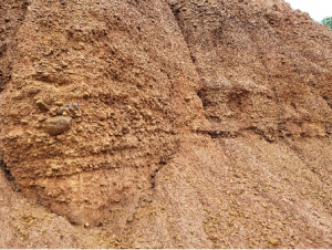
Investigating the origin of an anomalous white clay layer within the braided upland gravels on Crowleys Ridge: volcanic tephra, glacial slackwater lake deposit, or something else?
 M.S. student: Trevor Dempsey, 2020-2022
Collaborators:
Texas Tech University (Dr. Branimir Segvic)
Arkansas Geological Survey (Scott Ausbrooks)
This project is using XRD and geochemical analysis of a ubiquitous but anomalous clay layer that will be compared to determine its age and origin.
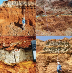
Images of a ubiquitous white clay layer in gravel pits on Crowleys Ridge
Luminescence dating of deep Mississippi valley alluvium and ground-truthing USGS airborne electromagnetic (AEM) profiles of the Mississippi alluvial aquifer using detailed analyses of rotosonic sediment cores
 M.S. student: Jodi Messick, 2020-2022
Collaborators:
US Geological Survey Lower Mississippi Water Science Center (Burke Minsley, JR Rigby, Ryan Adams)
U.S. Geological Survey Luminescence Dating Lab (Shannon Mahan)
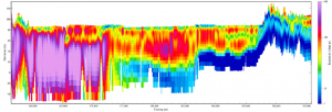
An example of an AEM profile across the Mississippi Embayment
Five 4-inch rotosonic cores were drilled in the Eastern and Western Lowlands, which are divided by Crowleys Ridge, in the summer of 2021 to understand unknown conductive layers identified in airborne AEM data. Up to 60 luminescence samples from the cores will help determine the ages and aggradational rates of the sediments that comprise the alluvial aquifer.
Upcoming Research
 Is the upland gravel stratigraphic unit of the Mississippi Embayment a Tertiary gravel deposited by a pre-glacial meandering paleo-Mississippi River, an early Pleistocene outwash gravel, both, or neither?
M.S. or Ph.D. student needed
Collaborators:
University of Memphis (Dr. Will Jackson)
This research will use measured sections and detailed sedimentologic characterizations, detrital zircons, GPR and ER geophysical surveys, and TCN and luminescence geochronology to determine provenance, the age, and origins of the enigmatic upland gravel complex.
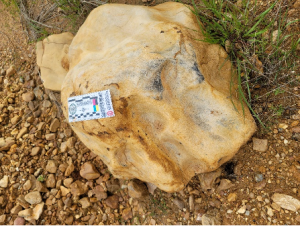
Images of the Upland gravel, which has been characterized as both a braided river deposit and as a meandering paleo-Mississippi River deposit. Large boulders are found in the deposit and suggest it is glacial outwash, yet published cosmogenic burial ages indicate it is 3-5 Ma and was deposited before continental glaciations began.
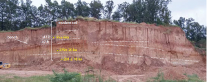
Developing a high-resolution, multi-proxy terrestrial paleoclimate record of the MIS 8 glacial period from loess on Crowleys Ridge.
 Ph.D. student needed
Collaborators:
Texas Tech University (Dr. Branimir Segvic)
Arkansas Geological Survey (Scott Ausbrooks)
Illinois State Geological Survey (Dave Grimley, Sebastien Huot)
Preliminary luminescence dating reveals that this thick loess section on Crowleys Ridge was deposited during MIS 8 and MIS 5c. Younger loess deposits are absent or very thin.
Luminescence dating revealed that nearly half of a 15m thick section of loess on Crowleys Ridge was deposited during MIS 8, making it one of the thickest known sections of loess from this glaciation in the Mississippi River valley. This project will collaborate with multiple researchers from other universities and will include detailed sampling of the loess for analyses that include total carbonate, magnetic susceptibility, XRD, XRF, spectrophotometry, particle size, stable oxygen and carbon isotopes, gastropods identifications, luminescence dating, and the analyses of detrital zircons and pollenLuminescence dating revealed that nearly half of a 15m thick section of loess on Crowleys Ridge was deposited during MIS 8, making it one of the thickest known sections of loess from this glaciation in the Mississippi River valley. This project will collaborate with multiple researchers from other universities and will include detailed sampling of the loess for analyses that include total carbonate, magnetic susceptibility, XRD, XRF, spectrophotometry, particle size, stable oxygen and carbon isotopes, gastropods identifications, luminescence dating, and the analyses of detrital zircons and pollen
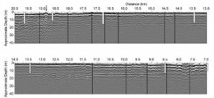
Where is the fault that produced the 1886 Charleston, South Carolina earthquake?
 M.S. or Ph.D. student needed
Collaborators:
NC State University (Dr. Lewis Owen)
U.S. Geological Survey Earthquake Hazards (Tom Pratt)
The fault that produced the Mw 7 earthquake in Charleston, South Carolina in 1886 remains unidentified, and in fact there are multiple competing models for where faults even exist in the Charleston area. Preliminary ground penetrating radar (GPR) data combined with reprocessed seismic data has identified several near-surface faults in the area. This project will build on that research and use high-resolution GPR and ER surveys to pinpoint faulted coastal plain horizons, drill sediment cores of the faulted horizons, use luminescence dating, and possibly open a trench for the purposes of locating the fault that produced the strongest historic earthquake to strike the eastern seaboard.
GPR profiles from the Charleston, SC area. Black lines are faults identified in deep seismic reflection, and white lines are boreholes used to calibrate for depth.
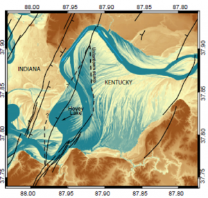
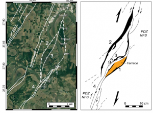
Investigating the Hovey lake fault system in the Wabash Valley seismic zone (WVSZ): understanding how Paleozoic structures created in a different stress regime are deformed by Holocene reactivation
 M.S. or Ph.D. student needed
Collaborators:
U.S. Geological Survey Earthquake Hazards (Bill Stephenson)
University of Kentucky (Dr. Ed Woolery)
Recently published research (Counts et al., 2021) identified a Holocene fault in the WVSZ that produced a >Mw 6.5 earthquake 3,500 years ago, which appears to be part of a large, reactivated structure. This project will build on that research and do a paleoseismic investigation of the Hovey lake fault using drilling, geophysics, luminescence dating, and trenching.
LiDAR (left) and aerial images (center) showing bedrock faults mapped by the USGS (solid lines) and inferred faults (dashed). The image on the right is a sandbox model (Dooley and McClay, 1997) of a strike-slip releasing bend that is remarkably similar to the Hovey Lake fault structure.
PUBLICATIONS
In review or revision
Pratt, T., Shah, A., Counts, R., Horton, W., and Chapman, M., in review, Shallow faulting in the epicentral area of the 1886 Charleston, South Carolina earthquake, submitted to the Bulletin of the Seismological Society of America.
Counts, R.C., Woolery, E., Van Arsdale, R., Mahon, S, Larsen, D., Price, A., Ward, A., Beck, E.G., and Nash, T., in review, Multiple episodes of Quaternay Displacement on the Meeman Shelby Fault, Eastern Arkansas, submitted to the Bulletin of the Seismological Society of America
Cox, R.T., Hatcher, R.D., Forman, S., Counts, R., Vaughn, J., Gamble, E., Glasbrenner, J., Warrell, K., Adhikari, N., and Pinardi, S.in review, Synthesis of recent paleoseismic research on Quaternary faulting in the Eastern Tennesse seismic Zone, Eastern North America: Implications for seismic hazard and intraplate seismicity, submitted to the Bulletin of the Seismological Society of America
Recent Publications, Accepted or Published
Dendy, Sarah N., Guenther, William R., Grimley, David A., Conroy, Jessica L., and Counts, R., in press, Detrital zircon geochronology and provenance of Pleistocene loess and contributing glacial sources, Midcontinental USA, Quaternary Science Reviews.
Pazzaglia, Frank j., Malenda, Helen, McGavick, Matthew, Raup, Cody, Carter, Mark, Berti, Claudio, Mahan, Shannon, Nelson, Michelle, Rittenour, Tammy, Counts, Ron, Willenbring, Jane, Germanoski, Dru, Peters, Steve, and Holt, William, in press. River terrace evidence of tectonic processes in the eastern North American plate interior, South Anna River, Virginia, Journal of Geology.
Grimley, D., Counts, R., Wang, H., Conroy, J., Dendy, S., Nield, C., 2020, Last glacial maximum ecological and climatic records from terrestrial gastropod assemblages in Peoria loess, western Kentucky, Journal of Quaternary Science early online publication, https://doi.org/10.1002/jqs.3206
Eason, A., Woolery, E., Counts, R., Van Arsdale, R., Larsen, D., Mahan,S., and Beck, G., 2019. Quaternary displacement on the Joiner Ridge Fault, eastern Arkansas, Seismological Research Letters,90, 2250-2261. https://doi.org/10.1785/0220190149
Cox, Randel T., Hatcher Jr., Robert D., Counts, Ronald C., Gamble, Eric, Glasbrener, Jake, and Warrell, Kathleen, 2018. Quaternary faulting along the Dandridge-Vonore fault zone in the Eastern Tennessee seismic zone, GSA Field Guides, 50, 81-94.
Warrell, Kathleen F., Cox, Randel T., Hatcher Jr., Robert D.,Vaughn, James D., and Counts, Ronald C., (2017). Paleoseismic evidence for multiple Mw ≥ 6 earthquakes in the East Tennessee seismic zone during the late Quaternary, Bulletin of the Seismological Society of America, 107, 1610-1624.
Ward, A., Counts, R., Van Arsdale, R., Larsen, D., and Mahan, S., 2017. Quaternary Displacement Rates on the Meeman-Shelby Fault and Joiner Ridge Horst, Eastern Arkansas: Results from Coring Mississippi River Alluvium Seismological Research Letters, 88, 442-455.